Robillard Plantation 1793 – Quartier Robillard 2022
Géricault Life
Image courtesy of Google Maps, 2022.
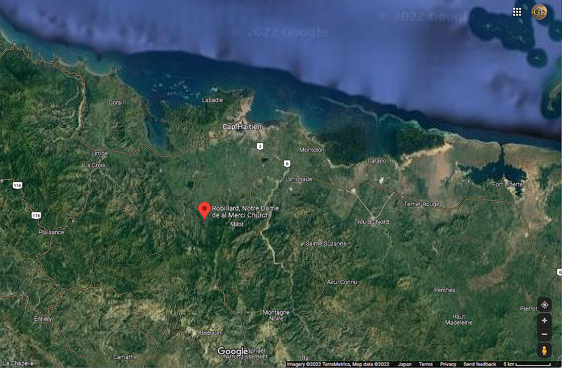
We open a new chapter in our examination of Théodore Géricault’s Saint Domingue relations with a discussion of Le Bonnet, the Robillard family plantation in Grand Boucan, and other Géricault family plantations in Haiti as they are today. The former plantation, known as Le Bonnet and Robillard in the 18th century and after, is now an agricultural community known as Robillard just south of Le Cap in northern Haiti. The screenshot above of Robillard is scaled to 200 meters. The screenshot below is scaled to 5 km. See the legend in the lower right, or click Google Maps to view these images in a new window. We begin with a discussion of the Le Bonnet plantation in Grand Boucan and then present a brief description of other Robillard plantations in northern Saint Domingue.

Image courtesy of Google Maps, 2022.
We have already discussed Géricault’s relation Jean Guillaume Robillard, who purchased Le Bonnet in 1772, in some detail. We will return to Jean Guillaume Robillard and Géricault’s Saint Domingue relations elsewhere. We note only that Jean Guillaume’s plantation was among the first to be attacked and burnt during the slave revolt of August, 1791, and that Jean Guillaume died at the plantation of his nephew in Borgne, in the mountains to the west, in 1794.
The Robillard plantation in Grand Boucan was 200 carreau dedicated to the production of sugar cane, or about 2.6 square kilometers, a sizeable piece of land, plus another 90 carrreau of pasture, and 50 carreau of wooded mountains.* This is important because it seems likely that at least part of the plantation was used for agricultural purposes even during the military campaigns which roiled the northern plains of Saint Domingue well into the 19th century, and certainly after.
The possibility of agricultural use for this large parcel of land is worth noting as the few records we possess of the period after 1791 identify the Robillard plantation as a military base. Antoine Dalmas, writing in 1814, identifies Macaya, an important military leader throughout the conflict, as “commandant du camp Robillard” in 1793. (Histoire de la Révolution de Saint-Domingue par M. Dalmas, Tome II Paris 1814, p. 220.) Was the “camp Robillard” located in Grand Boucan at the Robillard plantation. The following sources suggest so.
A.J.B. Bouvet de Cressé, in Histoire de la Catastrophe de Saint Domingue, Paris 1824, cites three letters from Henry Christophe placing the Haitian leader at the plantation on April 22, 1802 “Au quartier général de Robillard, Grand-Boucan, le 2 floréal, l’an 10. Le général de brigade, Henry Christophe, au général Leclerc.” (p. 111); “Au quartier général de Robillard, Grand-Boucan, le 2 floréal an 10. Le général de brigade Henry Christophe au général de division Hardy.” (p. 126); and “Au quartier général de Robillard, Grand-Boucan, le 2 floréal, l’an 10. Le général de brigade Henry Christophe, commandant le cordon du Nord, au commandant Vilton, à la Petite-Anse.” (p. 150)
We would prefer to possess additional letters on other dates to buttress the notion that Henry Christophe used the former Robillard plantation as his base on the northern plain. That said, Thomas Madiou, writes of Henry Christophe’s interest in a gunpowder manufactory which le Roi established at Robillard, Grand Boucan prior to 1815: “…il alla visiter une fabrique de poudre qu’il avait établie à Robillard, au Grand-Boucan, paroisse du Cap; mais toutes les matières premières, salpètre, souffre, etc. venaient d’Europe….” in Histoire d’Haiti de 1807 à 1843, Tome V, Port-au-Prince: Editions Henri Deschamps, 1988, (p. 318)
Late in the 19th century, Claudius Ganther in his Recuil des Lois et Actes de la République d’Haiti de 1887 à 1904 Tome I (1887-1894, par Claudius Ganther, Port-au-Prince: Chez l’Auteur, 1907, pp. 1018-1024) provides a detailed description of the law of 14 September, 1894, which defines the limits of the commune known as the Plaine de Nord, among other sites.
“De telle sorte que la commune de la Plaine-du-Nord est bornée: à l’ouest-nord ouest, au sud-sud-ouest, au sud-sud-est et au nord, par la commune de l’Acul-du-Nord; au nord-ouest et au nord, par celle de Milot. A Vaudreuil elle confine à celle du Cap. Elle se divise en cinq sections rurales, comme suit: …La cinquieme section, dite “Bassin-Diamant” commençant au nord-est au Bassin-Diamant, est bornée: au nord-est, par le confluent des eux de Galoir et des Campions, nommé “Bas-de-la Mer; ” au nord-ouest, par l’habitation Mathée, et au sud-ouest par les habitations Larevoir et Robillard.” (p. 1024)
Clément Murgue
Until yesterday afternoon, I had no plan to make this article my main focus in July. I had located the 19th-century sources, and 20 and 21st-century sources which allowed me to locate modern Robillard on Google Maps. Then I stumbled upon Clément Murgue’s 2009 agricultural dissertation on cacoa production in Haiti: “Diagnostic agraire: Le cacao, entre plaine et mornes dans le département du nord en Haïti.”
Murgue’s dissertation compares the agro-economics of cacao production in two communities in northern Haiti: Robillard in Grand Boucan, and Tibourg about 12 miles from Borgne, where Louis Robillard de Peronville and Charles Stanislas Robillard owned plantations. At this point, I regard Murgue’s treatise to be the most important source for those interested in the lives of those living and working on the Robillard plantations in Saint Domingue. Murgue’s discussion of the economics of life in Robillard and in Tibourg is compelling. Download Murgue’s dissertation here.
Murgue’s photos alllow us to step right into the space occupied by the Robillard plantation and meet people who are, in some cases, direct descendents of those who we struggle to identify and understand. Murgue writes about the land and the people of Robillard. Enjoy Murgue’s photos, informative writing, and the wonderful, hand-drawn illustrations. The landscape of Robillard may have changed a lot in the last two hundred years, but not much it seems. We will continue to examine archival and other documents connected to Théodore Géricault and his circle In the meantime, I encourage everyone to download Murgue dissertation and enter the land I had to this point only imagined.
Other Robillard and De Barras Plantations

Image courtesy of Google Maps, 2022.
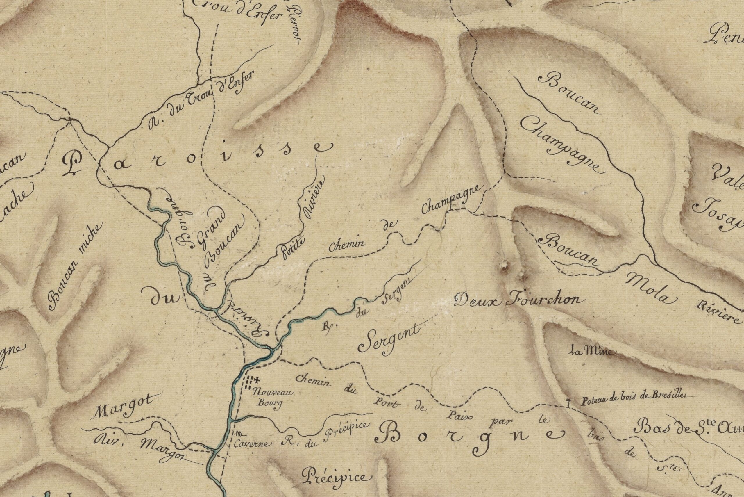
Jean Guillaume Robillard’s plantation is in blue. Plantations in yellow are those that can currently only be identifed by parish. I have yet to be able situate any of these plantations more precisely on any contemporary maps of Saint Domingue from the 18th century. Michel Robillard, an important Robillard relation in Saint Domingue we have not yet discussed, owned a plantation situated in Limbé. Katherine Roullit was born on the Roullit family plantation of Gros Morne. Charles Stanislas Robillard married Katherine Roullit in 1785. Their son Charles Joseph Robillard played an active part in Robillard family life in Paris. Charles Stanislas Robillard died in 1792, most likely in Saint Domingue. Charles Joseph Robillard inherited part of the Roullit plantation in Gros Morne and his father’s property in Borgne. Louis Robillard de Peronville’s plantation in Borgne was likely in Boucan Champagne on the map below. Claude de Barras, who Géricault met in Paris, owned at least two properties in Saint Domingue, one and Limonade and another with his brother, Étienne de Barras, in southern Saint Domingue (not visible here.) More to follow on all individuals and properties.

1750 Carte de la paroisse du Borgne à la côte Nord de St. Domingue, entre le Cap François et le Port de Paix (detail). Image courtesy of Gallica.